Big Bend National Park: A 3-Day Itinerary From Someone Who's Been Twice
Reviewed for accuracy on Apr 24, 2026
Big Bend is the most underrated National Park in the lower 48 and there are reasons. It's a long drive from anywhere — eight hours from Austin, four from El Paso, two from Marfa. There's no major airport. The cell service is essentially nonexistent inside the park. The summers are unsurvivable and the winters are tolerable only at higher elevations. None of that matters once you're standing at the mouth of Santa Elena Canyon and the Rio Grande is running emerald green between thousand-foot limestone walls.
I've been twice. First a four-day trip in November, second a three-day push in late March. The three-day version is the one I'd recommend to a first-timer who wants the highlights without losing a week. Here's how I'd run it.
Where to base yourself
The Chisos Mountain Lodge inside the park is the obvious choice — it's the only in-park lodging and the location is unbeatable, especially for early starts on the high-elevation hikes. It's also notoriously hard to book and the rooms are aggressively dated. Reserve six months out for spring or fall.
If you can't get the Chisos Lodge, the alternatives are Terlingua (15 minutes from the west park entrance) and Marathon (45 minutes from the north entrance). Terlingua wins for character — old mining town, quirky lodging, La Posada Milagro is the move. Marathon is more polished but adds an hour each way to your park time.
I've stayed both at the Chisos Lodge and in Terlingua. For a three-day trip, I'd take the Lodge if available; otherwise Terlingua hands-down for the proximity.
Day 1: Santa Elena Canyon and the Ross Maxwell
Get to the park early. If you're coming from outside, plan to be inside the gate by 8 AM. Day one is the western half of the park — the Ross Maxwell Scenic Drive, which dead-ends at Santa Elena Canyon.
Start with the drive itself. Pull off at every overlook — Mule Ears Viewpoint, the Sotol Vista, the Tuff Canyon stop. Sotol Vista is one of those views that doesn't photograph well and stuns in person. Make Cottonwood Campground your lunch stop — there are picnic tables in the shade of cottonwoods along the river, which is an oasis after the desert drive.
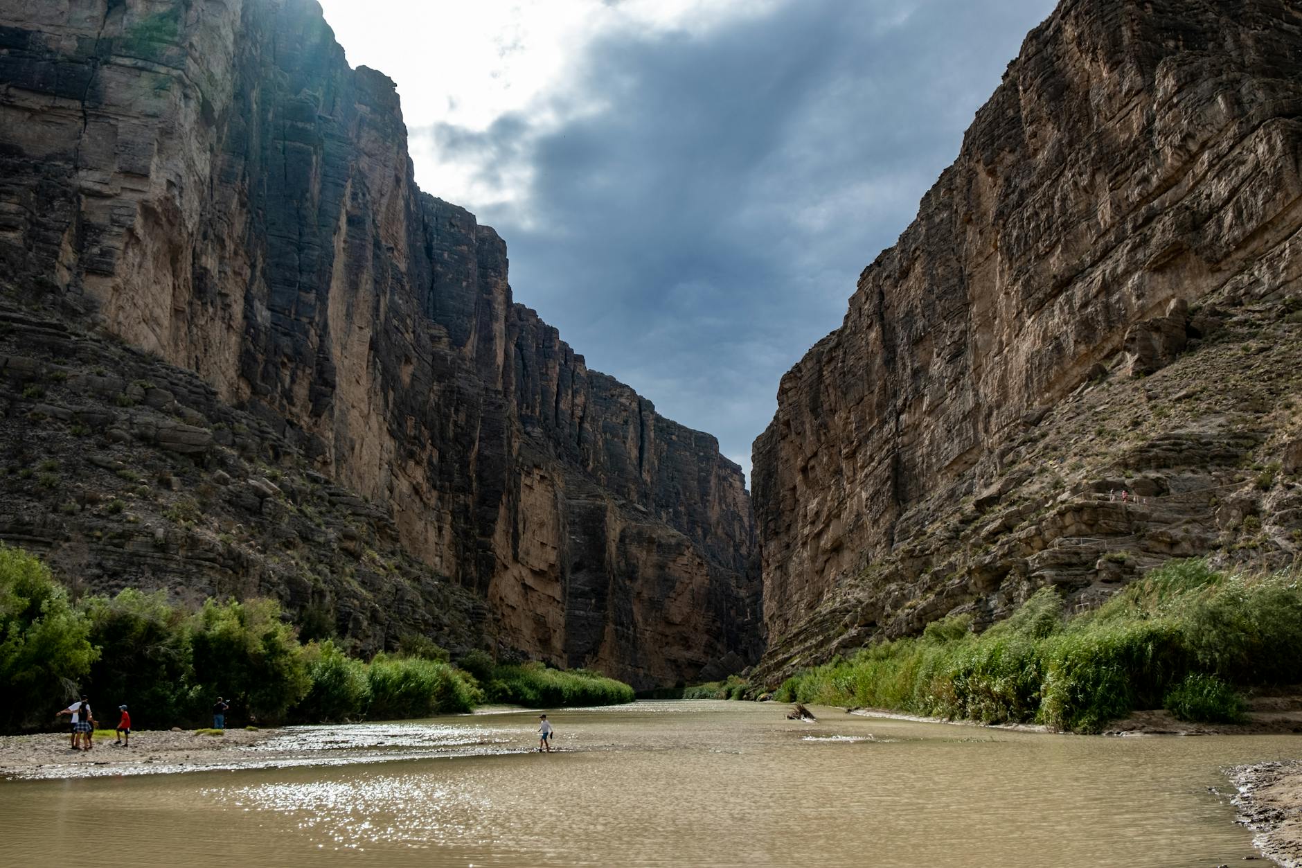
Hit Santa Elena Canyon in the afternoon when the light hits the western wall. The hike itself is short — 1.7 miles round-trip — but it crosses a small stream that's sometimes ankle-deep, sometimes shin-deep, depending on the season. You walk into the canyon mouth and the temperature drops 15 degrees. The light changes. You're suddenly between two cliffs that are taller than most skyscrapers and the river is doing its work right next to you.
Drive back to Chisos Basin or your lodging in time for sunset. The Window View at the Basin is the easy sunset. The actual Window Trail (a 5.6-mile out-and-back to the rocky pour-off) is better but you need to commit to it earlier in the afternoon.
Day 2: Lost Mine Trail and the Chisos
Day two is Chisos Basin day. Wake up early. The Chisos sit at 5,400 feet and the temperature differential vs. the desert floor is the whole reason they exist as a sane summer destination — but in winter and early spring, mornings can be in the 30s. Layer up.
Lost Mine Trail is the move for a first day in the Chisos. 4.8 miles round-trip, about 1,100 feet of elevation gain, and the payoff is a saddle view that opens onto Juniper Canyon and the Sierra del Carmen on the Mexican side. It's the most efficient "real Big Bend mountain hike" in the park. Start by 8 AM in spring/fall.
In the afternoon, do the Window Trail if you didn't get to it on day one — 5.6 miles round-trip, descends from the lodge area to the rocky pour-off where the basin drains. The hike out is the harder direction (it's all uphill on the return), so pace yourself and bring more water than you think you need.
For dinner, the Chisos Lodge restaurant is fine. Not great. The view of the Window at sunset from the dining room is what you're paying for — eat at 7 PM with the table angled west.
Big Bend's secret is that it's three parks stacked on top of each other — desert, mountains, and a 100-mile river canyon. You can't do all three properly in three days, but a Lost Mine sunrise plus a Santa Elena sunset gets you closer than you'd expect.
Day 3: Boquillas crossing and the hot springs
Day three is the eastern half. Drive over to the Rio Grande Village area, which sits along the river at the southeast corner of the park. Two stops here matter.
Boquillas del Carmen is the small Mexican village across the river from the park. There's an official border crossing — a small port of entry where you take a $5 rowboat across the river, walk or hire a burro into the village, eat lunch at one of the two restaurants (José Falcon's is the institution), and come back. Bring your passport. The crossing is open Wednesday through Sunday, 9 AM to 5 PM, and you must be back across before close. It's one of the most genuinely surreal experiences I've had in the U.S. — you're crossing an international border on a rowboat, walking up a dirt path into a village of 250 people, having huevos rancheros and a Tecate, and coming back. Plan three to four hours for the round trip.
Langford Hot Springs is a five-minute walk from a small parking area near Rio Grande Village. The hot spring sits in the foundation of an old bathhouse right at the river's edge — 105°F water in a stone pool, with the cooler Rio Grande right next to it for cold plunges. Go at golden hour. Bring a swimsuit and a towel. Don't expect to have it to yourself.
If you have time at the end, drive to the Rio Grande Village Nature Trail at sunset for a short, easy walk through cottonwood floodplain with a final overlook of the river.
What to pack
Big Bend rewards being prepared for the desert specifically:
- Water: more than you think. I bring 4L per person per day on the trail.
- Sun: wide-brim hat, sunscreen, long sleeves for the high-UV hikes
- Layers: mornings in the Chisos can be 30-40°F in spring; afternoons in the desert can hit 90°F
- Real shoes: trail runners minimum, not sneakers
- Cash: for the Boquillas crossing and the small village
- Passport: for Boquillas
- Offline maps: AllTrails offline downloads, Gaia GPS, or paper
What I'd do differently
I'd add a fourth day if I could swing it, specifically for the South Rim hike (12-13 miles, all-day commitment, the single best hike in the park) or for an actual rafting trip on the river. The three-day version covers the highlights but leaves the deep-cut experiences on the table.
I'd also stop trying to drive the entire park's road network. The distances inside the park are bigger than they look on the map, and a "scenic drive" can eat four hours of daylight. Pick two regions per day, max.
Final thoughts
Big Bend is one of those trips that doesn't make sense on paper and then makes complete sense the moment you're standing in Santa Elena Canyon. The drive is long, the logistics are real, and the payoff is one of the most spatially overwhelming places I've been in the United States. Combine it with Marfa for a full West Texas loop, or fly into El Paso and do Big Bend on its own. The Texas travel guide has more on the broader region.
Stay in the Loop
Get new photos, stories & exclusive deals straight to your inbox.
Related Posts
Dallas vs Houston vs Austin: Which Texas City to Visit First?
An honest comparison from someone who's been to all three: Dallas vs Houston vs Austin on food, culture, walkability, weather, and which one to visit first.
Best Texas Photo Spots (From Marfa to the Hill Country)
Texas photo spots from a photographer who's been: Hamilton Pool, Marfa at golden hour, Big Bend canyons, Austin skyline, Hill Country bluebonnets, and more.
San Antonio Riverwalk: Honest Take After Three Visits
An honest take on the San Antonio Riverwalk after three visits: what's tourist trap, what's actually great, and where to walk to escape the chain restaurants.